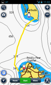
Due to provisioning delays and a charter briefing recommendation against overnighting in Dickenson Bay given the prevailing swells we wound up leaving for Barbuda from Five Islands Harbor so the passage would be about 5nm longer than anticipated.
Barbuda was the most ambitious passage of the trip so some planning had gone into it. Want to play along in order? You can read our passage plan to Barbuda here.

It was to be a reach in 12-15 knots so we figured on the 38′ catamaran we’d make good time. Still, to be on the safe side we got underway just after sunrise. As soon as we started making our way out of Five Islands Harbor we noticed the further from land we got the more wind we had. Once clear of Antigua’s wind shadow we we’re making 7-8 knots and being set west at about half a knot with about 16-19 knots apparent. It was fun sailing and everybody got a turn at the helm. We were on schedule for a noon arrival and by 11am we had sighted Barbuda.
At our charter briefing we were shown the few places in Barbuda that we were allowed to sail and anchor. We chose to head to the anchorage just west of Coco Point due to the swells out of the northwest. The paper chart provided by Sunsail, the chart on the chartplotter and the chart on my Navionics app each had dashed lines indicating safe approach bearings for getting into the anchorage. As instructed by the charter company we followed these courses in. All of our research into reef navigation was for naught, Sunsail had deemed all of the places where “visual reef navigation” might be necessary as off limits. I heard a rumor that they’ve had lots of damaged boats over the last couple of years so they’ve become much more vigilant: “No-Go” information for Sunsail Antigua.
We headed close hauled to sail in which was slower on the catamaran but not prohibitively so. We double checked that we were recording a track in case we had to head for sea due to unforeseen circumstances and couldn’t navigate out visually. We followed our friends on the 50’ monohull and the designated bearings in, rolled up the sails and started looking around for somewhere to anchor. The charts, shore, buoys, wave patterns and visible reefs painted a clear outline of where we’d be able to anchor.
All told we were having anchor beers by 1pm.
Leaving we had an even more ambitious plan, to sail down and around the Eastern coast of Antigua tying up at Nonsuch Bay. Once again we were on our way slightly after sunrise; following the lines on the chart and our entry track out the same way we came in. We had spent time snorkeling and dinghying around the reefs of the area to familiarize ourselves with visual reef navigation. On the way out, without the sun overhead, we were able to spot the reefs by observing the changes in the wave patterns which was a huge confidence boost.
I was left with the feeling that figuring out where you can’t go visually isn’t that difficult. It’s having confidence in where you can go that would give me pause…
If you’d like more information I put together this “video cruising guide” of our trip to Barbuda. I hope you find it helpful!
Ask question in the comments I’ll do my best to answer! Sign up below for access to un-published videos.
Leave a Reply